

ZZZZZZZZZZZZZZZZZZZZZZZZZZZZZZZZZZZZZZZZZZZZZZZZZZZZZZZZZZZZZZZZZ XXXXXXXXXXXXXXXXXXXXXXXXXXXXXXXXXXXXXXXXXXXXXXXXXXXXXXXXXXXXXXXXX ZZZZZZZZZZZZZZZZZZZZZZZZZZZZZZZZZZZZZZZZZZZZZZZZZZZZZZZZZZZZ
| CURRENT WEATHER AT BASIN, WYOMING 82410 | |||
|---|---|---|---|
| LAST READING AT TIME: 11:20 PM DATE: April 26 2024, time of next update: 11:30 pm | |||
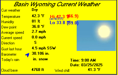
| Current Weather | Night time/Dry | Current Temperature | 49.3°F (9.6°C), Apparent temp 46.4°F |
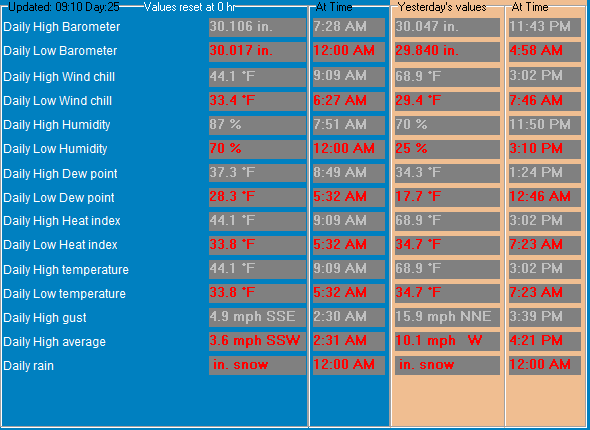
| Maximum Temperature (since midnight) | 59.9°F at: 1:03 PM | Minimum Temperature (since midnight) | 48.0°F at: 3:21 AM |
| Average windspeed (ten minute) | 0.8 mph | Wind Direction (ten minute) | NW (307°) |
| Windchill Temperature | 49.2°F | Maximum Gust (last hour) | 7 mph at: 10:57 PM |
| Maximum Gust (since midnight) | 11 mph at: 7:41 PM | Maximum 1 minute average (since midnight) | 9.2 mph at: 7:26 PM |
| Rainfall (last hour) | 0.000 in. (0.0 mm) | Rainfall (since midnight) | 0.000 in. (0.0 mm) --- |
| Rainfall This month | 0.83 in. (21.0 mm) | Rainfall To date this year | 1.024 in. (26.0 mm) |
| Maximum rain per minute (last hour) | 0.000 in/min | Maximum rain per hour (last 6 hours) | 0.000 in/hour |
| Yesterdays rainfall | 0.000 in | DewPoint | 36.8°F (Wet Bulb :43.9°F ) |
| Humidity | 62 %, Humidex 46.7°F | Barometer corrected to msl | 29.692 in. (1005.5 hPa) |
| Pressure change | 0.00 in. (last hour) | Trend (last hour) | STEADY |
| Pressure change (last 12 hours) | +0.06 in | Pressure change (last 6 hours) | +0.06 in |
| Current Indoor Temp. 71.1°F | |||
| Current Indoor hum. 24% | |||

SOUTH BIG HORN COUNTY AIRPORT , WY, United States (KGEY) 44-31N 108-05W 1191M
Apr 27, 2024 - 12:53 AM EDT / 2024.04.27 0453 UTC
Wind: from the WNW (290 degrees) at 7 MPH (6 KT):0
Visibility: 10 mile(s):0
Sky conditions: clear
Temperature: 48.0 F (8.9 C)
Dew Point: 37.9 F (3.3 C)
Relative Humidity: 67%
Pressure (altimeter): 29.75 in. Hg (1007 hPa)
ob: KGEY 270453Z AUTO 29006KT 10SM CLR 09/03 A2975 RMK AO2 SLP063 T00890033
cycle: 5
Amundsen-Scott South Pole Station, Antarctica (NZSP) 90-00S 00-00E 2835M
Apr 26, 2024 - 07:50 PM EDT / 2024.04.26 2350 UTC
Wind: from the N (360 degrees) at 13 MPH (11 KT):0
Visibility: 1 mile(s):0
Sky conditions: overcast
Weather: ice crystals; low drifting snow
Temperature: -74 F (-59 C)
Windchill: -112 F (-80 C):2
Pressure (altimeter): 28.12 in. Hg (952 hPa)
ob: NZSP 262350Z 36011KT 2400 IC DRSN OVC020 M59/ A2812 RMK CLN AIR 36012KT ALL WNDS GRID
cycle: 0
Alert Airport, Canada (CYLT) 82-31N 062-17W
Apr 27, 2024 - 12:00 AM EDT / 2024.04.27 0400 UTC
Wind: from the ESE (120 degrees) at 3 MPH (3 KT):0
Visibility: 15 mile(s):0
Sky conditions: mostly cloudy
Temperature: 12 F (-11 C)
Dew Point: 10 F (-12 C)
Relative Humidity: 92%
Pressure (altimeter): 29.86 in. Hg (1011 hPa)
ob: CYLT 270400Z 12003KT 15SM BKN200 M11/M12 A2986 RMK CI5 DENSITY ALT -3027FT SLP114
cycle: 4
Use the RELOAD facility on your browser to retrieve the latest data.